|
|
|

| |
 |
| |
| |
 |
| |
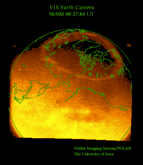
A view of the auroral oval taken by the Visible Imaging System
(VIS) on board the
Polar spacecraft, part of the
International Solar Terrestrial Physics (ISTP) program.
From the
VIS web page:
This picture shows a spectacular view of Earth as seen from the Polar
spacecraft from intermediate altitudes. The altitude of the spacecraft
is 25,740 km and the geographic latitude and longitude of its position
are 57.7° and 201.4°, respectively. The picture was taken at 00:37 UT
on March 25, 1996. Earth's northern auroral oval is seen as a "crown"
at the top of the image. The extended region of light in the center and
bottom of the image is the glow from the sun's illumination of Earth's
upper atmosphere. The filter for this image passes ultraviolet
emissions that are not directly visible to the human eye. The
intensities of this light from atomic oxygen in Earth's atmosphere at
altitudes in the range of about 100 to 500 km are color-coded in the
image with dark red as lowest intensities and whitish yellow as the
brightest intensities. A coastline has been superposed on the image.
Note that the aurora is positioned just north of the Great Lakes.
Advances in technology for the construction of these cameras allow
images of the auroral oval to be acquired for the sunlit atmosphere
with unprecedented clarity, as amply demonstrated by this picture of a
complete auroral oval that extends into the sunlit atmosphere.
The
image was taken with the Earth Camera that is one of three cameras in
the Visible Imaging System which was designed and constructed at The
University of Iowa.
The Principal Investigator is Dr. L. A. Frank and the Instrument
Scientist and Manager is Dr. John. B. Sigwarth.
|
|


